Saturday, April 30, 2011

Fitness Review - 4/30

This week was a bit rainy, but I snuck in the walks when I could.  Not as much training with the pack.  I really have to get on some trails, for walking in a business park can only do so good.      

Day Exercise Distance

(Miles)
Time

(Min)
Sun Walk.  1.5 30 min
Mon Wii, Walk (with pack) 1.5 60 min
Tue Wii 0.0 30 min
Wed Wii, Walk(with pack) 1.5 60 min
Thu Wii 0.0 30 min
Fri Wii, Walk (with pack) 1.5 90 min
Sat Wii, Walk. 2.5 75 min

Ending Weight: 207.7 lbs.  Gained back the 1.1 lbs. I lost last week.  Lucky the Easter Candy is almost gone. 

The Boy Scouts sort of had it right.

Another aspect of Personal Hygene is your clothing.  Sweat, dirt, dust, sunscreen, and bug repellent don't just collect on your body, they collect on your clothes as well.  Using a Boy Scout method (wearing the same clothes without washing) may be undesirable, it's not too far off.

The key to backpacking is getting clothing that you can wash easily.  You may wish to go hiking in jeans, but the thick cotton fabric makes them very unforgiving when washing.  The best clothing to use for this is lightweight, usually synthetic, breathable and something that dries easily.  One of the sources suggests that as soon as you make camp at the end of the day, change into "clean" clothes and wash out the clothes you are wearing.  Assuming it's not raining, that gives your clothes all evening and night to dry, and by the time you pack them, they should be dry.

When cleaning the clothes, it's sufficient to rinse them off in water.  People have been washing clothes that way for millenium, only recently have we decided that we need soap to make them truly clean.  (I won't suggest that you beat them together between rocks like cavemen, but you get the drift.)

So the Boy Scouts sort of had it right, wear the same clothes all the time.  Just take a lesson from their mothers too, wash your clothes. 

Friday, April 29, 2011

Bird Baths

Bathing poses a problem for a hiker.  The most effective way, hopping in a pond, is challenging when the water has just melted from ice or snow.  If you've got unlimited amount of fuel, you can heat up enough water to take a shower, however, that is also not practical.  So you're limited to what we called as a child "Bird Baths": heating up a pot of water and spashing it on your body. 

The key here is washing where you need to.  The key is to concentrate on areas that sweat and have skin on skin contact.  Arm pits, groin area and between toes are areas where sweat and dirt tend to congregate and begin forming rashes.  Untreated, this can lead to open sores, blistering and pain. 

So, bring a pot for boiling some water (even lukewarm is better than freezing), some biodegradable soap, a washcloth or sponge and a quick dry towel.  Find a somewhat secluded area at least 200 feet from a water source, and give yourself a quick bird bath.  

Wednesday, April 27, 2011

What's that smell?

Imagine walking with 40 lbs on your back for 5 or more hours in the sun while it's hot outside.  Naturally, you're going to sweat.  Now imagine doing this for 12 straight days without a decent shower.  Then imagine having your loved one pick you up to drive you home.  Only the strongest of marriages can survive such an ordeal. 

Face it, on the trail, I'm going to stink.  I'm sure I'll be sweating profusely, and deodorant is a no-no (the scent tends to attract bugs).  I'm sure I'll be slathering on the sunblock, since anything less than SPF 30 will leave me lobsterlike.  And then there's the DEET, which is used liberally by tree huggers and back to nature dwellers everywhere to keep the mosquitoes away.  (Ironic, isn't it?) 

Apparently, according to Rick and Allen, I'll get used to the "clean is a relative term" concept and won't mind it if my nasal cavities are scrubbed away by the stench.  They say that a quick dip in a stream is probably the most effective way of cleaning yourself off.  (The emphasis will be on the quick part, given that the stream started from a glacier a mile or two upstream.)  If my experience with the pond is anything, I shouldn't feel any extremities in less than a minute.  Hypothermia is your friend. 

Tuesday, April 26, 2011

Hand Washing

Every backpacking source that I've read have been emphatic about the importance of hand washing on the trail.  They point to the case that normal rules you use at home should be the same as on the trail (wash after using the toilet, before and after cooking, and before eating).  These are just much harder to do when there isn't a steady stream of sanitary water coming from a faucet. 

There are different ways to clean your hands, but the easiest are the hand sanitizers.  These are great for sanitizing hands before eating, for they are very effective at killing off germs and other nasties.  What they don't do is clean your hands of dirt and other crud.  For that, plain old soap and water are required.  However, soap can be unhealthy for the environment, particularly if the phosphates in the soap get into the water supply and create algae blooms.   So, I'll need to get some special soap that doesn't have any phosphates. 

When setting up a washing station in camp, the standard is to set it up 200 feet from camp, and 200 feet from a water source.  The objective is to let the water, soap and any dirt soak into the ground and allow the ground to use it as a filter.  Don't pour it on any vegetation, for it may kill it or animals may dig it up if there's something tasty in the water.  (Apparently, the animals on the mountain will find most anything tasty.) 

So, the rule seems to be, keep them clean to avoid the spread of disease.  Didn't we learn that in the 1700's? 

Monday, April 25, 2011

Day in the Pond

Since it was a nice day on Saturday, I spent much of the day cleaning out the pond in the back yard.  Our fish pond is not like one of those anteseptic, cute ponds that you see in the Martha Steward magazines.  No, our pond is au-natural, that is, trying to become a swamp by filling itself it with detritus.  So once per year, in a vain attempt to keep some water in place for the fish to swim in, I climb in and scrape out a bunch of mostly pine needles. 

Saturday was that day.  The air temperature was in the 60's, however, the water temperature was in the 40's.  I got it halfway pumped out before I had to climb in.  After losing all the feeling in my feet and having the nerves in my hands tingling because of the cold, I fished out what I could and called it a day. 

That got me to thinking, though, what about hygiene on the trail?  Skinny Dipping in glacier runoff can be seen as a sure-fire way to hypothermia.  So, I guess I'll have to do some research and share with you what I find out about keeping yourself sort of clean on the trail. 

Fitness Review - 4/23

Ended the week with a beautiful day in the Northwest.  Sunny and in the 60's, I took the opportunity to do some yard work, most notably cleaning out the pond.    

Day Exercise Distance

(Miles)
Time

(Min)
Sun Walk.  1.5 30 min
Mon Wii, Walk (with pack) 1.5 60 min
Tue Wii, Walk (no pack) 3.0 90 min
Wed Wii, Walk 1.5 60 min
Thu Wii, Walk (with pack) 1.5 60 min
Fri Golf 2.5 90 min
Sat Yard Work 0.0 180 min

Ending Weight: 206.6 lbs, down another 1.1 lbs.

Saturday, April 23, 2011

Keep your Stuff Dry.

When it begins to rain, and the rain begins to soak through your pack, the water in the rain starts to get everything in the pack wet.  Remember, water weighs a bit over 8 lbs per gallon, so your pack can quickly turn into a lead weight if you're not careful. 

One solution to this is to buy a raincoat for your pack.  Called pack covers, they usually have drawstrings to cover your pack so that it doesn't get wet.  Allen & Mike, however, have a better idea.  Use a heavy duty garbage bag and put it inside the pack.  It will save on weight and on the pocket book. 

The downside is that the pack itself will get wet in the face of a rainstorm.  The upside is that if needed, the bag can be used for many other things.  One rule of backpacking is to bring as many multi-use items as possible. 

Friday, April 22, 2011

Gear: Not an Emergency Poncho


Water on the inside of your body is vital to health and well being.  Water on the outside can be annoying, heavy or at worst, dangerous.  Being cold and wet while hiking all day isn't really my idea of fun.

Mount Rainer sits on the windward side of the Cascade Mountain Range, and as such, forces moist air upward over the range as it moves inland.  As air moves upward, it gets colder and as it get colder, it gets drier.  Thus producing precipitation, hopefully rain.

We have to be prepared for all types of weather conditions on the mountain, including rain.  So rain gear is an essential when those summer squalls hit.  If just taking a day hike, one can easily just pack an emergency poncho, little more than a plastic bag to wear over you to keep out the majority of the water.  However, this poncho is frail, easily ripped, and traps moisture inside as effectively as it traps it outside.  What we really need is some good rain gear.  Although I own about 6 rain coats (I do live in a rain forest, you know), I'm not certain what I'm going to bring yet.

So, I'll keep my Emergency Poncho in my fanny pack (for those day trips) and figure out something else to take along before I head out. 

Thursday, April 21, 2011

Gear: Water Filter

Another way to get potable water from a stream is to use a water filtration device.  The one I use is a a Katadyn Hiker model.  When assembled, you pump the water through a prefilter in a water source (which gets out all the big stuff), then through a 0.3 micron glassfiber (no cleaning needed) Activated carbon granulate filter which strains out all the bad stuff.  (Can you tell what part of that sentence is marketing buzzmumble?) 

The capacity of this model is approximately 1 quart per minute, so generally it takes longer to set up than to fill a bottle.   Over the life of the product, the filter is rated for 200 gallons.  Shouldn't need another one for this trip. 

Neither the chemical method or the filter method is foolproof, so the experts recommend using both.

Unfortunately, this filter weighs about a pound.  However, if it provides quick and easy water source, and keeps me on the trail and out of the hospital, I'll gladly carry it.

Wednesday, April 20, 2011

Gear: Water Treatment

The water you're going to get on a hike isn't from a tap, doesn't come from a treatment plant, and doesn't come in a cute plastic bottle that you can get by the case at Costco.  It comes from nature.  By nature, that could mean glacier runoff, rainfall, snow melt, or underground spring.  Needless to say, it's full of contaminants from air pollution and whatever interesting chemicals it runs across as it finds its way downhill.  (Remember, Mount Rainier is a volcano, and volcanoes are the largest sulfur dioxide polluters in Washington.)   

Although the water may have chemicals, the larger issue is the bacteria that lives in the water.  Water contaminated with chemicals tastes really bad, but it generally will keep you alive.  Water contaminated with bacteria will make you really mad in a few hours while you're emptying your digestive system any way possible.

The classic response to this is to boil the water.  In the field, though, this presents some problems with the amount of time it takes (up to an hour), the fuel it uses (which you're carrying on your back), and the non-transportable nature of the process.  It's hard to carry something when it's on fire.

So part of any backpacker's kit is more chemicals to kill off all those pesky bacteria.  The bottle with the white cap contains Tetraglycine Hydroperiodide which you add to the water and let dissolve for 30 minutes.  You then follow it with a pill from the bottle with the yellow cap that precipitates the iodine and other chemicals out of the solution.  It is then mostly safe to drink.  You can stop, fill up your bottle, pop the pill in it and be on the trail in a matter of minutes.

Tuesday, April 19, 2011

God's Little Tricks, or Water.

Hiking up and down hills takes a lot of energy.  With that as well, the human body uses quite a bit of water via persperation, or old fashion sweat.  According to Allen & Mike, you will need 3-4 quarts of water per day.  That translates into 8.35 lbs of water that you'll either need to carry with you or find along the way.

Of course, you will need to carry the water in something.  We have a cute little stainless steel water bottle that we picked up at a store somewhere on sale.  It looks to hold about 16 fl oz. and weighs about 5 oz.  However, according to Allen & Mike, carrying the fancy water bottle is just a waste.  They suggest that you take an old plastic Coke bottle, clean it out, and use it for your water supply.  The plastic bottle weighs only about 1 oz. and you won't be using it long enough for nasty chemicals to leach out too much.

I'll probably end up with the Coke bottle method, since I regularly do what you're not supposed to do and refill plastic water bottles from the tap.  I also save quite a bit of money not buying a skid of water every week.

The unfortunate part about finding water on the trail, though, is that it's usually at the bottom of the hill.  The trail usually crosses a stream, then goes up to the top of a ridge, where it's barren.  I guess I'll just have to figure on carrying that 8.35 lbs of water up the hill with me on a daily basis.

Thanks, God.  Gravity is fine most of the time, but sometimes it's just a bit inconvenient.

Monday, April 18, 2011

Water Week.

This week I'll be blogging about Water, one of the four ancient elements.  Air is very important while hiking, though there's not much to say about it.  Fire is forbidden in the back country, visions of Yellowstone going up in flames is enough to make any ranger cry.  Earth, well that's important too, but other than walking on it, it's just kind of dirt. 

Water, on the other hand, is something special.  Hikers have to plan water stops.  Without water, a hiker cannot last long.  Water's heavy and it's vital.  So during hiking, you have to plan to take water. 

An average hiker will require between 3 and 4 quarts of water in a day.  Of course, that varies depending on temperature, the exertion level, and a number of other factors.  Needless to say, good trail guides will denote where a water stop is.  And usually when they talk about water stops, they aren't talking about a faucet in the middle of nowhere.  It's a source of water.  What you do with it is, well, that's the trick. 

Sunday, April 17, 2011

Fitness Review - 4/16

Slow progress this week.  Lost a little weight and had a couple of busy nights.  The weekend turned into a bust, though, with most of Saturday trying (and failing) to put a trailer hitch on the new car.  

Day Exercise Distance

(Miles)
Time

(Min)
Sun Walk.  1.5 30 min
Mon Wii, Walk 1.5 60 min
Tue Wii, Walk (with pack) 1.5 60 min
Wed Wii, Walk (with pack) 1.5 60 min
Thu Wii, Walk (with pack) 1.5 60 min
Fri Golf 5.0 210 min
Sat Wii 0.0 30 min

Ending Weight: 207.7 lbs, down another 0.2 lbs. 

Indian Henry

National Parks seem permanent.  When we enter into them, we see these rustic signs and structures and believe that it has been there since the dawn of time.  Then when we start poking around, we find that there are old homesteads that have been restored and are kept as reminders of how things were in the past.  Other times, we just notice some decaying fence or structure and wonder about where it comes from.

On Day 2 of the hike, we pass through Indian Henry's Hunting Ground.  Indian Henry was a Caucasian name taken by an Indian named Sotolick (although many variations of the spelling exist).  He was a contemporary to James Longmire and lived in the area with his three wives.  His hunting ground is known for its brilliant displays of wild flowers, rivaling that of Paradise. 

The Indian Henry Hunting Ground in the National Park was named to honor him for he was often found there in the fall hunting while his women picked berries.  Satulick Mountain which is east of the Hunting Ground was named to honor Indian Henry.

There are a few tales that are attributed to Indian Henry which may be found in the references, however the one that I like is that he is alledged to have changed the signs on the road to the mountain to pass by his property so that he could sell the travellers food and supplies.  If true, I salute Indian Henry for capitalism and opportunism is not solely the domain of the "white man". 

References:

Saturday, April 16, 2011

Day 2 - Devil's Dream to South Puyallup River

The second day of the journey takes us through Indian Henry's Hunting Ground and over Emerald Ridge.  It starts off with a 1.3 mile stroll up Devil's Dream Creek and up to the Patrol Cabin.  This is the high point of the elevation at 5300 feet for the first part of the day. 

From there, the next 1.4 miles is basically straight down.  It drops 1000 feet to Tahoma Creek.  The trail takes a hard right and the slog starts all over again, 1300 foot elevation gain in 2.2 miles.  Given we're going to go down just about as far, we'll have wished that the drilled a tunnel through Emerald Ridge when we're done. 

After reaching the ridgeline, we drop faster than we climb, losing 1400 feet in 1.4 miles.  With weary legs, going down will be just as tiring as going up. 

This evening, we'll be camping at South Puyallup River (Pyew-al-up) campground. 

Friday, April 15, 2011

Kautz Creek History

On Day 1, the Wonderland Trail crosses Kautz Creek.  This creek originates at Kautz Glacier and is a tributary of the Nisqually River.  The creek is notorious for being a severe flooding hazard.  According to the USGS, On October 2 and 3, 1947, heavy rains triggered a jökalhaup (glacial lake outburst flood) from the Kautz Glacier- the largest flood after the establishment of the park.

Having lived here for 10 years, I can attest that at times we can get massive rainstorms.  In 2006, over 18 inches of rain fell on Mount Rainier in 36 hours, causing flooding, washing out of roads and the disappearance of an entire campground.  This event in 1947 caused a mudflow that went for 6 miles downstream.  However, that's just one of the ways that nature changes the landscape around us. 

Back to Kautz Creek, the creek is named for the glacier, which was named after August Kautz, who in 1857 supposedly was the first person of European descent to climb Mount Rainier.  Born in Germany, he emigrated with his parents to America and enlisted in the Union Army for the Mexican-American War.  Stationed out in the Northwest after the war, he is noted for defending Chief Leschi, a Nisqually Indian Chief who was wrongly convicted of murder and executed. 

I encourage you to look at the Wikipedia references.  Too often we pass by oddly named landmarks without really understanding where the names came from.  I learned about August Kautz simply because his name happened to be on a map.

Thursday, April 14, 2011

How to Read Topographic Maps

As a tool for displaying information, a topographic map probably compresses more information into one square inch of space than just about anything else.  Topographic Maps are essential tools to have on the trail for if you have one and you are lost, you can determine where you are.  If you have a map and a compass, you're almost there.  If you have Latitude and Longitude coordinates, you're golden.  (However, if you know your Latitude and Longitude, you probably have a GPS and you can use that to find your way home.)

A topographic map is a visual representation of the contours of the land.  I've attached a map of the first leg of the trip, the hike from Longmire to Devil's Dream. 

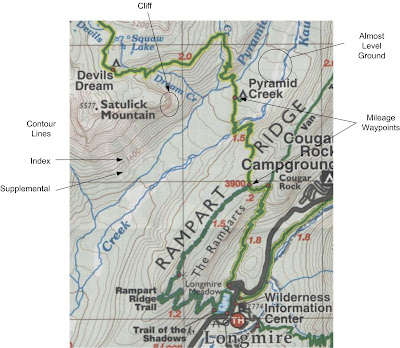
You will notice that there's all sorts of lines on this map, kind of like fingerprints almost.  These are called Contour Lines.  Mapmakers (generally, the US Geological Survey) looked at the elevation of the land and drew these contour lines to indicate how high the particular point is from Sea Level.  Since this is a US map, those elevations are shown in feet. 

Index contour lines are a bit darker than the others, for they are at key elevations.  On this particular map, they are every 400 feet, with four supplemental lines between them, each 80 feet apart.  When these lines are far apart, that means that the overall terrain is gently sloping.  When the lines are very close together, this signifies a very steep slope, even a cliff.  One of the rules of topographic map making is that contour lines cannot cross, so near cliffs, the lines are almost on top of each other. 

The Wonderland Trail on this map is shown in a green and yellow line (obviously Green Bay Packers fans). 
Every so often along the trail, you will see a red dot.  That dot is used as a mileage waypoint.  Generally, a map maker will place these where two trails meet or at a significant point.  Distance between waypoints is almost always listed, on this map in comforting red numbers signifying approximately how many miles between waypoints. Upon occasion there is also a red number indicating the approximate elevation of a particular waypoint. 

So, in looking at the map, you can see what kind of hike you have.  Starting from Longmire (elevation 2774), you have about a 1.8 mile climb of about 1000 feet to the intersection of the Van Trump Park Trail (of which you can only see the "Van" part of the name).  0.2 miles further, you walk along the side of the slope to the intersection of the Rampart Ridge Trail.  You then walk another 1.5 miles to the Pyramid Creek campsite (signified by the little tent).  This part actually goes down a couple of hundred feet to where it crosses Kautz Creek and is almost level to the campsite. 

After Pyramid Creek, that's where the going gets rough.  In the next two miles, you will notice that the trail wiggles quite a bit.  Those are switchbacks, and they are put in trails when the slope of the hill is so steep you pass from the realm of hiking to the realm of mountain climbing.  Another 1000 feet higher or so, you arrive at Devil's Dream campsite.  This is where you take your boots off, pop a half a dozen Advil, and rest. 

So, that is what I'm planning for my first day on the trail.  Two long slogs up hill interrupted with a little bit of almost level ground. 

Map is courtesy of Green Trails Maps.  If you want to learn more than you want to know about Topographic Map Symbols, check out the USGS Topographic Map Symbols booklet.  They do this stuff for a living. 

No, the other East.

I grew up in Wisconsin, with Lake Michigan to the East.  I went to school in Virginia, with the Atlantic Ocean to the East.  I lived in St. Louis, with the Mississippi River to the East.  My world has large bodies of water to the east.

Once I moved out to the Pacific Northwest, that all changed.  Suddenly, the Puget Sound (or Salish Sea as they now would like to refer to it) is to the west.  So is the Pacific Ocean.  An my grandfather would say, "This is backwards and wrong."

I've been out here ten years, and I still get on the highway going East to go toward the water.  When giving directions, I still have to think hard about which way is East.  Mostly, though, it's just a verbal and written hangup.  When I see a map, I know which way is east.  That is good, for when I start having to read maps when I'm on the trail, it would really be bad if I started walking East.  No, the other East.

Whatever!

Wednesday, April 13, 2011

Food Caches

When planning a hike of any duration, one obvious question is "How much food do I have to bring?"  The easy answer is "How many days are you hiking?"  The nice thing about the Wonderland Trail is that there are Ranger Stations where you can drop off food to pick up on your journey. 

Along the Wonderland Trail, there are opportunities to drop food off at Longmire in the southwest, Mowich Lake along the west, Carbon River in the northwest, and Sunrise and White River Campground in the north east.  If you have the ability to have someone meet you, you can also meet up with people when you cross the road at Box Canyon in the southeast.  

Based on my desired Itinerary, it looks like the longest stretch that we would have between food caches would be 5 days at the beginning of the trip.  I do not relish carrying 12 days of food, so I will definitely be taking advantage of these places to drop off food. 

What type of food?  Well, that would be for another post. 

Tuesday, April 12, 2011

When to Go.

So, one of my Type A daughters, Corinne, is enviously reading these posts and is trying to figure out how to work it into her schedule.  You see, she's graduating from Carnegie-Mellon University in May and is one of the lucky graduates that have a job lined up.  However, before she joins the rat race, she wants to see the world (some more).  She's scheduled a trip to Scandanavia and Scotland for the month after her graduation, returns home for a month, then is planning on travelling with Gail and Valerie to Italy and other European destinations this summer.  She talked her new employer into not letting her start until August so that she can have her cake and eat it too! 

She'd like to come with me, however, it only fits into her schedule if we go during the first half of July.  I'm a bit nervous about hiking at that elevation that early in the summer because there is still snow at many of those elevations, making life a bit more challenging.  Two of the ranger stations along the route, Mowich Lake and Sunrise, don't open until the beginning of July.  If this year is any measure, it's been a pretty wet spring, particularly in the mountains. 

So, I need to do some more investigation, for although I'd love to spend a couple of weeks with my daughter, I also would hate for it to end up in a helicopter rescue from a freak spring snowstorm. 

(Note, for those of you who are not used to a Mountain climate, July may seem pretty late for spring to arrive.  The flora and fauna up in the mountains are used to a flurry of activity virtually as soon as they detect sunlight.  I would strongly suggest that you put a trip to a mountain meadow on one of your summer trips, the floral display at times is stunning.)  

Monday, April 11, 2011

Three days? Right!

After church on Sunday, we were talking to some friends of ours, Sue and Sonny.  Gail and Sue were teachers together a couple of years ago and we got to know them better watching their son Conrad playing for Jackson High School.  He's a senior trying to make the difficult decision about where to go to college, play football for Lewis and Clark College, or enroll in the Engineering School at Hawaii.  No bad choices either way!

During the conversation, we were talking about our summer plans, and I mentioned to Sonny that I was going on this 93 mile hike around Mount Ranier.  Sonny's response:  "So, how long is it going to take you?   About three days?"  Sonny, you see, is a Army Reservist.  Going through drills every month and spending a tour of duty in Iraq a couple of years ago, he sees this as a weekend bivouac. 

Needless to say, I'm looking at more of a 12 day trip.  I'm not looking for a death march.

Saturday, April 9, 2011

Geocaching in the Afternoon.

So, it wasn't enough fun to hike around with the backpack on in the morning, we decided that since the weather was still cooperating, we'd go out for a little walk with the dog and a little geocaching.  3 miles later, we returned, finding 5 caches along the way.  The dog enjoyed it, and amazingly enough, the sun was out long enough that we actually had to take our coats off because it was getting too hot. 

Of course, the only reason I wanted to do this post is because of the cool screen shots that I can do on the GPS.  Maybe one of these days, I'll get tired of it, but right now, it's just fun. 

They didn't throw me out of Starbucks.

A member of our church is trying to get a Men's Bible Study/Fellowship group started, and we decided we'd have an organizational meeting at Starbucks.  The Starbucks is only about 2 miles from my house, so I decided that if the weather cooperated, I'd strap on the backpack and get some training in.  So, I woke up and although it was a bit chilly, the hike to Starbucks was uneventful. 

The looks I got, though, when I walked in were priceless.  I should have ordered before I took off my backpack to see what they'd say.  That could have been interesting. 

By the end of the morning, I'd walked about 4.5 miles (with very little elevation change) without too hard of an effort.  The exercise and training seems to be paying off, for I can see my stamina increasing, my weight is dropping and although my legs are sore at the end of the day, they're not so sore that I can't function. 

I'm starting to believe that I can actually accomplish this.  Now all I have to do is find a companion. 

Fitness Review - 4/9

Spring Break was this week, which helped muddle up the schedule a bit.  Started the week off with a good hike, and I kept up the Wii program, however, hiking with the backpack wasn't as consistent as I would have liked.  Did finish the week with about 7 miles logged, though.

Day Exercise Distance

(Miles)
Time

(Min)
Sun Hike (with pack).  2.5 120 min
Mon Wii, Walk 1.5 60 min
Tue Wii, Walk 1.5 60 min
Wed Wii, Walk (with 28 lb. pack) 1.5 60 min
Thu Wii, Visit Tulip Farms 0.0 30 min
Fri Wii, Walk 1.5 30 min
Sat Walks 4.5 w/ Pack
3.x without
210 min

Ending Weight: 207.9 lbs, down another 1.1 lbs.  This is as low as the Wii has ever measured me (i.e, in over 3 years.)

Monday, April 4, 2011

My First Reference Book.

I've mentioned Bette Filley's Discovering the Wonders of the Wonderland Trail encircling Mount Rainer and Rick Curtis' Backpackers' Field Manual, but long before I got those books, I had another book that started it all.  It's hard to remember, but I believe that it started out when Gail and I were browsing some National Park bookstore, and I saw this book I couldn't resist:  Allen and Mike's Really Cook Backpackin' Book: Traveling and camping sklls for a wilderness environment! by Allen O'Bannon and illustrations by Mike Clelland.  I've had it so long, I've just found it again.  In the bookshelf, of all places! 

The name kind of gives you an idea of the flavor of this book.  Part tongue in cheek, part lessons learned, part redneck backpacking, this book is short and sweet and gives you a whole lot of info crammed into 155 pages.  Along with a few laughs.

For instance, the section about packing your backpack basically says to eschew the fancy packing sacks and compression bags, they just add weight.  Treat your backpack like a big bag and shove stuff into it.  No one cares about wrinkles on the trail.  So, my task is to compare all the different advice and figure out what I want to do for myself.

Sunday, April 3, 2011

Training along the Sound.

For today being the nice day of the weekend, it didn't seem like it.  The sun never did come out, although you could see a lighter round spot.  It was chilly, and it seems like I was cold all day.  Enough whining!

Since it didn't rain, we took the dog on a little walk down to Meadowdale Park.  In the Pacific Northwest, they tend to make parks out of anything that they cannot put a house on.  Thus, most of Meadowdale Park is filled by Lund's Gulch.  Not a gulch as you would think of in a western movie, but more of a gulch you would think of in a jungle (sorry, rainforest is the PC term).  So the hike today was 1.25 miles down the hill and 1.25 miles back up the hill.  It ends at the Sound in one of our typically gravelly beaches.  We didn't tarry long on the beach, for the wind was blowing and it was a bit on the chilly side.   

We did manage to find one Geocache today, however, the two other ones we looked for were either muggled (stolen) or misplaced.  We did manage to figure out how to take pictures on the GPS.  I'll include a couple so we can see how they look. 

When the GPS takes a picture, it embeds the location where the picture was taken, and after doing so, it then shows it on the map.  My screen shot here was taken after the pictures were taken off the camera, so the screen is less cluttered.  (In one of those "Well, duh!" moments, I discovered that if you turn the screen sideways, your picture is wider than tall!)   

Saturday, April 2, 2011

Geocaching? Hiking? no, Shopping.

Garrison Keillor is coming to Saint Michelle Winery and Ticketmaster had a $12.50 surcharge per ticket to buy a $39 ticket, a 32% premium.  Not wanting to get ripped off by monopolistic money grabbers, Gail and I decided to drive down to the Winery today (it's only about 15 miles away at the most).  So, while we were down there, we figured we'd go geocaching.  We found about half a dozen along the Sammamish River Trail so I thought I'd strap on my backpack and get some exercise in. 

The tickets were bought, but we managed one geocache before the sky turned dark and it began to rain.  Given that the forecast was supposed to be for rain, rain and more rain, we decided to head home.  Unfortunately, we had to drive by Woodinville on the way back home, past Sir Plus, an Army surplus store.  I love surplus stores, mostly because you never know what you'll find.  We stopped in there, and I picked up an Ammo can (for hiding a geocache), a rain coat, and Gail got two pair of gloves.  All for less than $40.  We decided not to get any MREs (Tuna and Tortellini), a spork, Camo clothes or bullet shells.  Then we went to Petsmart to get dog treats (since Zoe was with us).

By the time we got home, the sun was out again, so we took our standard walk around the neighborhood.  It started sprinkling by the time we got home.  It would have been nicer going along the trail, but I'm also not one that's going to get soaked when I don't have to.  It's supposed to be nicer tomorrow, so I'm thinking on heading down to Meadowdale Beach Park.  That's a 2.5 to 3 mile hike down Lunds Gulch to the Sound.

Fitness Review - 4/2

I started training this week with a backpack and my new hiking boots.  The backpack weighs just short of 30 lbs stuffed with rags, paper and golf balls.   Unfortunately, rain and work commitments helped derail the end of the week. 

Day Exercise Distance

(Miles)
Time

(Min)
Sun Just a bit of yard work 0.0 60 min
Mon Wii, Walk (with 28 lb. pack) 1.5 60 min
Tue Wii, Walk (with 28 lb. pack) 1.5 60 min
Wed Wii, Walk (with 28 lb. pack) 1.5 60 min
Thu Wii  0.0 30 min
Fri None 0.0 0 min
Sat Wii, Walk (with 28 lb. pack) 1.8 75 min

Ending Weight: 209.0 lbs, down .9 lbs.  According to Wii Fit, I crossed the line from Obese to Overweight today.   I'm happy about that. 

Friday, April 1, 2011

Who's that Homeless Guy wandering around?

So, on Monday I started walking around the business park where I work with this 28 lb. backpack on.  I also brought in my new hiking boots to start to bring them in.  My typical noontime walk is a 1.5 mile route that I get done in 25-30 minutes.  Usually, I carry a grip strengthener because a few years ago I had a bit of a run in with tendinitis and the physical therapist gave me some exercises to strengthen my grip and exercise my arms.  I guess the people in the neighborhood have gotten used to this bearded dude wandering around doing Nazi salutes at lunchtime.

On Monday, though, some bearded dude was now wandering around with a big backpack on his back.  This is a prestigious community, they generally don't let people like that just wander around at lunchtime.  Most cars that drove by gave me a double take trying to figure out what was up with that.  Before I got back to my desk, I had three people ask me what the blazes was going on.  Did my wife throw me out?  Did the bank take away the house?

So I sent out a notice to everyone at work on Monday telling them that, No, I wasn't losing my house or wife, just maybe my mind.  I explained to them about my quest, what windmills were in my way, and how I was preparing for it.  I also gave them the link to this blog, so we'll see if my stats go up.