Sunday, July 31, 2011

Signs of Civilization

Remains of Wooden Pipe
As I approached Carter Falls, I saw an unusual coil of wire in the ground.  Obviously man made, this wire looked continuous and wound its way through the woods.  As I travelled further down the trail, I could coils of wire along with some wooden stakes.  It kind of looked like a barrel with no ends. 

Wooden Pipe along Trail
Finally, as I passed the falls, the origin of the wire became obvious.  It was the remains of a large wooden pipe.  In doing a bit more research, the trail was passing by an old electric power generating station that used to supply electricity to Longmire.  The pipe diverted water around the falls to power the generators.

Although information is not complete, the pipe seems to date from before the 1920's.  (Cast Iron pipe became readily available after then.)  There are no signs of the power plant anymore.  The only signs of civilization I saw at the site was a small metal pipe protruding from the ground and a the end of a large cable. 

This is an example of how temporary human structures can be.  Within 50 years, the forest has all but reclaimed most elements of civilization. 

Saturday, July 30, 2011

Douglas Fir Roots

Douglas Fir Tree Fall
As I was proceeding down the trail toward Carter Falls, I came across a recent tree fall. I thought it would be a good opportunity to demonstrate the root structure of the type of forest on Mount Rainier.

Douglas Firs can grow to be huge trees, upwards of 400+ feet (125m) tall and 15 feet (5m) in diameter.  Although this tree was not that tall, my crude measurements had it at about 150 feet (45m) tall before it fell.  To give you some scale, the tree sticking out to the left in this photo is approximately 6 feet (2m) off the ground.  That means that the main root structure to support this tree is about 15 feet (5m) in diameter.  When looking at the side view, you can tell that the roots for this tree are maybe 5 feet thick (<2m) at the widest.  

Side View of the Root Structure
It seems incredible that a tree that size can remain standing with that small of a base.  The reason that they don't fall over more often is that the roots of neighboring trees intertwine, forming a mesh that helps keep the trees upright.  Treefalls such as this usually begin a cascade of fallen trees because the support for all the roots are removed, making them much more unstable. 

In urban areas in the Northwest, it is understood that when a number of large trees are removed, the remaining trees are very susceptible to being blown down in wind storms. 


Paradise River Crossing

Paradise River Bridge
The crossing of Paradise River is immediately after Paradise River Camp.  This bridge is the first of three bridges over the channels of the Paradise River.  During my trip, the first channel had the largest water flow, the second channel was dry and the third channel had just a trickle.  Snowmelt in the spring moves quite a bit of rock and debris which reroutes the river almost every year. 

The Park Service did a good job of rebuilding these bridges recently.  The remains of the old log crossing were still visible downstream.  (I noticed that the maintenance of this trail was virtually impeccable.  Three cheers for the maintenance crew.) 

The old Bridge
The River is accessible here to obtain water (properly filtered or treated) or to just soak your toes.  Not deep enough to go swimming, even if you enjoyed swimming in near freezing water. 

Friday, July 29, 2011

Paradise River Camp


About 0.7 miles (1.1km) down from Narada Falls lies Paradise River Camp.  This camp, mere meters from the Paradise River crossing, has 3 sites, 1 group site and toilet facilities.  Site #1 is wide and narrow, 20 feet (6m) wide and only about 9 feet (3m) deep.  However, there are not many tree roots.  Site #2 is 15 feet by 25 feet (5m x 7m) and is the farthest from the center of the camp.  The small path to the site can easily be mistaken as a stream bed and was a bit damp on one side.  Site #3 is the same size as #2, but two large trees encroach on either side.  Sleeping on roots is a real possibility


Group Site
The group site was nicely sized at 15 feet (3m) by 40' (12m).  There was even a split log that could be used as a serving table in the group site (upper right in the photo).

The Bear Pole was centrally located, and the toilet was off in the woods approximately 250 feet (75m) from the rest of the camp.  There was plenty of privacy insofar as the toilet was screened from the camp and trail, however, if you camp there, you may wish to institute some type of "in use" warning so that you don't walk up on your fellow camper. 

Toilet ...
... with a view
As with all back country camps, no fires are allowed.   Water is easily accessible at the Paradise River crossing. 


Thursday, July 28, 2011

Reflection Lake

Reflection Lake
Shortly before noon, I pulled into Reflection Lakes.  Right on the Steven's Canyon Road, there was quite a bit of traffic, but the sight was worth it.  The trails leading from Reflection Lakes were still covered in snow, but with the help of others' footprints, I found the trail without an issue.

The lake was still but only about half melted.  Large portions of ice were still on the lake.  However, there was one area in the ice flow that melted in about the same shape as the mountain.  By far my best photograph of the day.

After having a little rest and a snack, I decided to head back down when I saw a stream coming in across the road.  Only about the last 30 feet (10m) were visible, but you could hear the water echoing underneath the snow. 

Stream feeding the Lake
The trip back to Narada Falls was uneventful.  I warned a group from England that there was a snowfield ahead and given their footwear, they decided to turn back.  The mothers and their preteen sons, however, thought it was cool and couldn't wait until they found the snow.

Wednesday, July 27, 2011

High Point

Avalanche Lily
The first leg of the hike from Narada Falls to Reflection Lakes is a series of switchbacks gaining approximately 400 feet in elevation.  Relatively steep, this section was partially snow covered until I reached the high point on the trail (about 3/4 mile - 1.2km).   The sun was shining that day and there were a number of Avalanche Lilies blooming along the side of the trail.  There were a half-dozen downed trees but none of them impassible. 

The view from the high point is tantalizing, but merely a foretaste of the views from Reflection Lakes. As soon as I turned the corner for the final push to the lake, the snow began to be pervasive.  Half following the trail and half pioneering, the snow was solid enough to walk on but a bit interesting in places where the slope was steep.  The last 1000 feet (300m) before crossing the road I had to bail out of the snow and follow the road.  That gave me the opportunity to stumble across some Phlox, a welcome sight.  

Tantalizing View

It was much easier returning to Narada Falls having come from there.   If I had started at Reflection Lakes, I wouldn't have known where to find the trail near the road.  The sign at the road crossing points down to a large snowfield. 

Tuesday, July 26, 2011

Narada Falls

Narada Falls
Although technically not on the Wonderland Trail, Narada Falls is within sight of the trail junction.  It is easy to get to, either by driving or using the shuttle bus.  I took the shuttle bus and planned to walk back down to Longmire.  I started off at approximately 10:30 am with partly cloudy skies and 65 degrees F. 

The falls plunge about 170 feet (57m) right next to the parking area.  As you can see from the from the photographs, the water was running high.  At the top of the falls is a stunning view down the Paradise River Canyon. 

The hike descends rough hewn stairs to a viewing area.  Be careful, they are often wet and slippery.  The temperature cooled significantly as the evaporating effects of the water cooled the air.  The second tier viewing area was enveloped in mist, making it a wonderful way to cool off.  If you're coming down from Reflection Lakes and heading to Longmire, the natural air conditioning is well worth the short side trip. 

Bridge over Paradise River at the top of the Falls
The name Narada was proposed by Arthur F. Knight and adopted in 1893 for the Narada branch of the Theosophical Society of Tacoma. Narada is a Hindu word meaning 'uncontaminated' or 'pure'.

View from Parking Lot

Monday, July 25, 2011

Second Leg - Reflection Lakes to Longmire


I hiked the second leg of my journey on July 24th between Reflection Lakes and Longmire.  Although not contiguous with the first leg, it had the benefit of being mostly snow free. 

This leg of the trail was made possible by the Shuttle Bus service at Mount Rainier.  I parked at Longmire, took the bus up to Narada Falls, hiked up to Reflection Lakes and then back.  It was a beautiful day, about 65 degrees F when I started. 

The section between Narada Falls and Reflection Lakes included an elevation gain of approximately 500 feet (150m) which I then retraced as I hiked down to Longmire, a loss of approximately 2100 feet (640m).  One of the most heavily travelled parts of the Wonderland Trail, I saw scores of other hikers, mostly between Cougar Rock campground and Carter Falls. 

Most of the snow that I encountered was near Reflection Lakes, but it felt good on the feet on a nice, summer day. 

Thursday, July 21, 2011

Flora and Fauna on the Trail

The last blog entry about this leg is primarily just to share with you some pictures of wildlife.
Vanilla Leaf

From a animal standpoint, we scared an elk who bounded off not more than 100 feet from us.  She was rude enough not to stick around for a picture.  Heard quite a few birds, saw the usual contingent of squirrels, a snake a a bit of bear scat.

From a flora perspective, the Vanilla Leaf was in bloom, saw a number of Trillium, mostly purple but some white, Indian Paintbrush, blooming Salmonberry and a number of other flowers we didn't identify.


The most interesting picture we saw was a mature tree growing from the rotted out stump of a snag.  With this picture, it's not very easy to see, but it was kind of cool. 

Corinne takes pretty good pictures of flowers.  

Tree growing up in a snag

Another Flower


Trillium

Tuesday, July 19, 2011

Lions and Tigers and Bears, Oh My!

We forgot to take a picture of the Scat,
so you'll have to settle for a snake instead.


While hiking along the Wonderland Trail, we had to avoid a number of different piles of scat.  We recognized the scat from a deer (small pellets), though we were stumped when we got to the larger, blackish brown piles.  It almost reminded me of horse droppings, though, the trail does not allow horses.  After we returned from the hike, we asked a park ranger at the Visitor's Center, and she told us it was from a black bear (which I confirmed later here).  There were either a large number of bears, or they just like using the Wonderland Trail for a toilet, for we had to dodge about a dozen piles. 

This, of course, brought up the famous refrain from the Wizard of Oz, which we just happened to have seen at the Benaroya Hall with the Seattle Symphony playing the soundtrack a few nights earlier.  Which leads me to the parking garage and the unexpected reserved spaces for Electric Vehicles.  Having just purchased a Nissan Leaf about a month ago, I was pleasantly surprised when I got into the parking garage and found reserved parking for Electric Vehicles closer than the Handicapped spots.  Needless to say, I pulled in, plugged in, and enjoyed the show.

However, I'm still waiting for my Polar Bear hug.

Monday, July 18, 2011

Confirmation

There's always that nagging voice in my head that says "This is crazy.  You can't do it.  You're not strong enough/young enough/hardy enough/determined enough/fill in the blank enough."  It comes and goes depending on how much my knees hurt or how many other activities in life interrupt my preparation.  So this first leg was meant as much as a training exercise as it was a journey.

Yes, my knees hurt a and my legs are tired, but it gives me comfort that I can do this. It was not exactly like I planned it; I only carried a day pack.  I didn't make it through the entire segment and I didn't follow up the hike by sleeping on the ground.  It was, though, an accomplishment.

Over the course of 6 hours, we hiked 10 miles with an elevation gain of 1500' (450m) in two segments (and of course, a loss of 1500').  I did have to stop to catch my breath on a couple of segments, but I kept plugging along.

(The elevation profile of this leg is a little misleading.  The scale along the bottom is 1.5 miles (2.4 km), whereas the elevation scale is 400' (120m).  And don't believe the numbers at the top.  I really haven't figured out all the options on this GPS yet.  )   

Overall, it was a good day.  I got my first taste of the Wonderland Trail, I got to spend the day with my daughter, and I got confirmation that I can do this.

Sunday, July 17, 2011

Martha Falls.

Martha Falls was the destination for our hike today, and it proved to be a worthy trip.  To a certain extent, though, it is a bittersweet destination.  The falls are comprised of a number of smaller falls with a total drop of 665 feet from the first to the last.  The portion of the falls that is visible from the Wonderland Trail is only about 60 feet, so we only saw a small portion of the falls.  That didn't stop us from taking a seat and having our lunch.

Unfortunately, one cannot see the entire falls at once.  The topmost falls plunge between 50 and 60 feet, but cannot be seen.  The second falls makes a beautiful fan shape as it plunges the next 125 feet.  After 175 feet of cascades, the 60 foot falls shown here is visible.  After channeling through a narrow gorge, the final falls plunges 160 feet into the valley base.  Certain portions of the falls may be seen from the Steven Canyon Valley road above, but you have to walk up and down the road to get various angles.

Of course, like most Mount Rainier streams, it is wild and temperamental.  The collection of debris at the base of these falls extends down stream and took out the bridge over Unicorn Creek.  The trail service put in a log bridge and alternative hiking path, making crossing possible, but I would be cautious with small children. 

Martha Falls was named for Martha Longmire in the late 1880's by her son Ben.  More information may be found at Northwest Waterfall Survey

Saturday, July 16, 2011

Rock Slide

Rock Slide
One of my favorite phrases is Pyroclastic Flow; it just rolls off the tongue.  It's a fast moving current of superheated gas and rock.  It's what comes out of the ground when volcanoes explode like Mount Saint Helens on May 18, 1980 or what buried Pompeii in AD 79.  What's left over after one of these eruptions is a large amount of rock, ash and other debris.  Evidence of pyroclastic flows and volcanic eruptions is evident around Mount Rainer.

Mount Rainier is an active volcano, last erupting in 1894.  As we walked this segment of the Wonderland Trail, the soil is basically volcanic ash.  Somewhere between the consistency of sand and dust, this material is everywhere and in large amounts.  When an entire hillside is made of the remains of a pyroclastic flow, it is not very stable. 

Just before Martha Falls on the Wonderland Trail, there is a rock slide where the remains of a pyroclastic flow is still moving.  This rock slide was identified by the park service and temporarily repaired by the trail crews, but it is obvious when you're on it that it is not stable.  It is not dangerous, per se, but anyone trying to run up a sand dune will tell you that at times you just find yourself at the bottom.  Just stay on the trail and don't linger. 

It is obvious that this section of the trail will be washed out again this winter if no other work is done to stabilize or reroute the trail.  However, it may not be possible given the current route to stabilize the trail.  A large bridge structure just west of the rock slide was destroyed recently.  Evidence of multiple rock slides were apparent along this segment of the trail. 

Friday, July 15, 2011

Sylvia Falls

Andesite Columns
Between Maple Creek Campground and Sylvia Falls, the trail follows the Steven's Creek bottom.  The creek meanders along a valley between 10 and 300 feet wide, continually scouring new channels each year with the spring runoff.  Shortly upstream of Maple Creek Campground, Steven's Creek looked to be making a new channel through a forested area. 

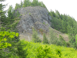
Along this section of the hike, we passed what looked to be an old Lava Flow on the left.  This cliff is comprised of andesite columns, made from hardening of lava flows from the mountain's past.  What I found interesting about this cliff is that the lava flow at the bottom is coming in at a 60 degree angle to the flow straight up, indicating that eruption chamber was not altogether vertical. 

Several times on the trail it crossed into the creek bottom, making it less like a trail and more like scrambling over boulders.  Large talus fields on the left pointed to the gradual decomposition of the andesite columns, which would then be eroded into football sized rocks.  This was the sunniest part of the trail, however, the cloud cover kept the temperature down. 

Sylvia Falls
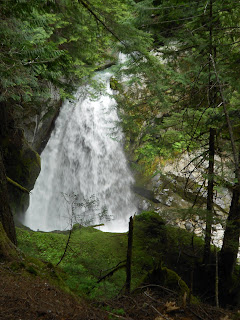
After about 1.3 miles (2km), the trail passes back into the woods and next to Sylvia Falls.  According to Northwest Waterfall Survey, these falls were named by a park ranger William Stafford after a female acquaintance.  I can only imagine that he took a fancy to her.  

We stopped to rest in this peaceful setting.  It's not the largest waterfall by any means, but it is the first one we saw on the trail.  There's nothing like the first one. 

Thursday, July 14, 2011

Maple Creek Campground

Site 1
Maple Creek Campground is located approximately 1 mile west of the Steven's Creek Crossing.  The campground contains 4 sites, 1 group site and toilet facilities.  Water is available at the stream and bear poles are provided for hanging food.

It is a backcountry campground, so each site is little more than a cleared area in the forest.  There's plenty of shade, but no amenities such as a picnic table or fire pit.  (Open fires are specifically banned in backcountry campgrounds, taking a bit off the traditional camping experience.)

Toilet w/ Privacy Screen
Composting Toilet
I was pleasantly surprised at the toilet facilities.  Most back country toilets are little more than boxes out in the middle of the forest.  This was actually a composting toilet with a privacy screen!  I was a bit confused by the sign on the toilet, though.  It read "Women, please do not urinate in the composter.  Please urinate in the woods.  Place the TP in the composter."  Does that mean men can pee in the composter, or do they assume that men are just going to pee anywhere they want? I'm assuming that they only want #2 in the toilet.  Bring your own paper! 


Bear Pole
Another key requirement in the back country is food storage.  Storing food in the tent is not smart for bears don't care if you're in there or not.  The campground had a Bear Pole; a metal tube in the ground to hoist food up on.  It was not nearly as strong as I had thought, but I guess it does the job. 

Random Tidbit (about Snow)

Crystal Mountain is a ski area just to the east of Mount Rainier.  Today, they announced that the ski area will close this Saturday (July 16th).  The ski season was open for 9 months this year. 

Corinne and I followed a couple of boarders home from the mountain on Saturday, so we figured they were still open. 

This was made possible by 51 feet (15m) of snow this year. 

Wednesday, July 13, 2011

Steven's Creek Crossing.

The first segment of the trail was downhill to Steven's Creek.  The trail passed through wooded areas and downhill.  At first the descent was gradual, however, about halfway down (.7 miles, 1km ) the trail turns sharply right and the descent increases.  There is a large rock here with what used to be a nice view of the canyon and Mount Adams, however, the trees have grown and obscured the view.

At the bottom of the hill there is a nice wooden bridge over the Steven's Creek.  As you can see from the picture, the creek is not wide but is running swiftly.  The water has polished the rocks smooth.  At this point, the creek is not accessible, however, farther up the trail it will be.  As you can also see, flooding does pick up trees and other debris (and if I was a betting man, the old Steven's Creek Bridge).

Also as you can see, my lovely daughter accompanied me today.  Although the bridge looks natural, they hid the Steel I-Beams nicely underneath the bridge.

The trail turns to follow the creek uphill after the bridge, so we quickly shed our long sleeves.

Tuesday, July 12, 2011

Box Canyon

We started the hike at Box Canyon.  This is a popular stop by the road, for it is unusual.  The Canyon has been carved by the Muddy Fork of the Cowlitz River through a fissure in the rock.  If you look carefully, you can see a rushing river 100' below the bridge running through a channel 5 feet wide.  

(Geology buffs can learn an overiew from the Box Canyon geocache or can do a deep dive in the Roadside Geology of Mount Rainier.)  

This section of the Wonderland trail goes down into Steven's Canyon, so naturally, we went up some switchbacks to pass over the road over the tunnel.  I was wary when the first switchback we encountered had a little stream running through it.  I thought that foreshadowed a muddy day on the trail, but I was wrong.  The trail was in great condition, almost completely dry, and clear of all snow.  
The trail paralleled Box Canyon for awhile before it took a right turn as we descended into Steven's Creek Canyon.  And thus, at 9:15am on July 10th, we were on our way.  


Of course, every beginning has to have the obligatory "I was here" photo. 

Monday, July 11, 2011

First Leg Completed!

It's going to be a difficult year to get this accomplished.  As I stated before, a through hike trail is all but impossible due to the demand and the amount of snow.  So after a couple of weeks of summer activity, I decided it was time to make a start on this.  I selected the only section of the trail that wasn't snowed in, a section between Box Canyon and Martha Falls on the southern side of the mountain. 

My daughter and I hiked this on Sunday, July 10th on a perfect day.  51 degrees F when we started, the day never got too hot and the partly cloudy skies kept us cool for the day. 

The trail from Box Canyon started with a 500' (150m) descent into Steven's Creek Canyon, then a gradual climb up about 1100' (330m) to our destination, Martha Falls.  Along the way we saw a blooming wildflowers, a female elk, bear scat and crossed a treacherous rock fall. But those are the subject of future posts. 

As for now, I can say the journey officially has begun.