Wednesday, August 1, 2012

Practice Hike - North Fork Sauk River Trail

Last weekend we did our first practice hike.  The weather finally quit raining and we were able to test out our gear. 

Not knowing where to go, I called the Darrington Ranger Station and asked about a hike I saw online, the North Fork Sauk River Trail.  It looked appealing because it was about 5 miles to a campground, and another at about 3.5 miles (if we had to bail) and it only had an elevation gain of about 800 feet. 

So, we set out from home about 11am and after 17 miles on gravel roads, we got on the trail about 1:30.  The three of us strapped on our backpacks and up we went.  It was a forested hike, the only view is the one in the photo above.  About 2 miles up the trail, we stopped for a little break and a snack.  At the first campground, we stopped again for a break and a snack.  About 5:30, we finally got to our campground and our legs were aching. 
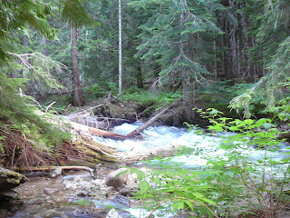
The hike was pleasant, along a river but not right next to the river.  There were noisy areas where the water was rushing through the rapids and quiet areas where it was a bit calmer.  We hiked through old growth forests, next to talus fields and forded streams.  We were passed by others hiking all the way up to Glacier Peak to go climbing or skiing. 

When we got to the campground, we setup the tent, fired up the stove and tried the reconstituted dried Beef Stroganoff.  We learned that if you don't stir it up, you get a serving of beef first, followed by a serving of noodles.

Exhausted, we went to bed early after a bit of reading and a card game.  The weather was good for sleeping, chilly but not cold.  We kept warm in our sleeping bags, even if the ground was a bit hard.  We were not exhausted the next day, so we must have gotten our rest.   

The way back on Sunday was easier, going downhill, but we still felt it in our hip flexors and hamstrings.  By the time we got to the car, we were stinky, tired, and ready to drive to Darrington for some food.  A burger and fries lasted until we got home.  We exhausted the dog so much that she slept for the next two days. 

It was difficult, but fun.  It's giving me second thoughts about the itinerary, since we'll be doing 5 miles on a short day and almost twice that much on the long days.  This may kill me yet. 


Thursday, May 17, 2012

2012 Itinerary - Wonderland Trail Northern Loop

I got my reservations in and have a five day excursion planned for the end of August.  This is a rough outline of the Itinerary. 

First Day - Sunrise to Mystic Camp
Elevation Gain 1,990', Loss 2,570' - 9.5 Miles

Starting at Sunrise (ele 6400'), the trail varies between 6,400 and 6,700 feet for the first 3 miles.  At Skyscraper mountain, the trail descends in the next 4 miles to Winthrop Creek at 4,600 feet before climbing to Mystic Camp at 5700 feet.

Second Day - Mystic Camp to Carbon River Camp
Elevation Gain 300, Loss 2,900 - 5.2 Miles

The second day is the easiest day of the trip, losing about 3000 after climbing out of Mystic Lake.  Most of the day is hiking along Carbon Glacier, so it ought to be cool.  This is a rest for the next two days.

Third Day - Carbon River Camp to James Camp
Elevation Gain 3,340', Loss 1,900' - 6.2 Miles

Probably the most grueling day of the itinerary, the first mile is 400' down to the Carbon River Crossing, and the next 4 miles climbs 3000' up to Windy Gap.  From there, the last two miles drops about 1,500' to James Camp.

Fourth Day - James Camp to Fire Creek Camp
Elevation Gain 1,800', Loss 1,100' - 5.5 Miles

The first 2 miles drops 1,100' to the White River crossing then climbs 1,800' in the next 3 miles to Fire Creek Campground

Fifth Day - Fire Creek Camp to Sunrise
Elevation Gain 1,800', Loss 300.  - 8 miles 

Noted as the longest level stretch of trail in Mount Rainier, the last day climbs 900' to Grand Park in the first 2 miles.  The next 3 miles is level through Grand Park before it climbs 900' from Berkeley Park to Frozen Lake.  Then it's just a mile or so downhill to Sunrise, the Car, and the rest of the world.  

Wednesday, May 16, 2012

Training Hike - Poo Poo Point

The day before Mother's Day we hiked up to a popular paragliding spot on Tiger Mountain.  Affectionately known as Poo Poo Point, we decided to go on a beautiful day in the spring.  The temperature was in the low 70's and the sky was clear.

The hike consisted of 3 miles straight up (1,800 feet) a slight descent, then level to the point.  After a rest watching people flying away, we went back down the way we came. 

On the day we were there, a local company was doing tandem rides.  One toddler was not very happy her mother was flying away, for she was crying the whole time Mom was getting ready to take off.  Didn't phase the mother, though, for as she left the ground, she waved and said "Happy Mother's Day". 


Wednesday, April 4, 2012

Martha Falls Redux

Martha Falls
The trail from Louise Lake to Martha Falls was fairly uneventful.   The first leg between the lake and the Stevens Canyon Road crossing was fairly open with fairly frequent sneak peeks at the mountain.  The Trail between the road crossing (4500 ft) and the Falls was more heavily forested with little underbrush.

Unlike my first visit, I was accompanied this time by my lovely bride.  We met a man and his son trekking around the mountain and had a little chat.  He was about my age and his son was soon to graduate from college.  He had always dreamed about making the hike around the mountain and finally figured it was the right time.

Needless to say, his son was leading the way up the hill. 
The happy couple

Hidden Lake?

Between Reflection Lakes and Martha Falls, you come upon a lake hidden in between a couple of ridges.  You can't see this lake very well from the highway, and the Wonderland Trail skirts the lake.  However, just as you are descending from the intersection with the trail to Sluiskin Falls, you get a glimpse of a wonderful little alpine lake.

The lake is called Louise Lake, and there is a little side trail off the Wonderland Trail to get down to the lake.  There was a man fishing there, however, we were not sure if he had caught anything. 
The lake looked to have no stream coming out of it.  The outlet into Sunbeam Creek was fairly well hidden, flowing out of a narrow valley on the northeast part of the lake.  (Upper right corner of the first photograph.)  The lake was fed by a couple of minor creeks, barely visible through the trees. 


Faraway Rock

Labor Day Weekend - 2011

I was unloading pictures from the camera the other day and I found there were a number of pictures from Labor Day last year.  My lovely bride and I took a hike on the Wonderland Trail between Reflections Lakes and Martha Falls.  It was a gorgeous day for a hike. 

As you can see from the pictures, the sky was clear and the mountain was out.  However, there was still snow that we had to walk over. 


For 2011, the Wonderland Trail never did become snow free.  The trail along the eastern edge had snow patches that never melted.  The elevation at Reflection Lakes (48xx feet) is almost 2000 feet below the highest elevation at Panhandle Gap. 

We can only hope for better weather in 2012. 

Tuesday, April 3, 2012

Fourth Leg - Reflection Lakes to Martha Falls


This is the bookend to the final hike on Labor Day last year.  We started at Reflection Lakes and went down hill to Martha Falls.  As you see from the elevation profile, it then became a bit of a climb.

Total hike for the day was about 7 miles, 3.5 miles each way.

With this hike, I completed the southern part of the Wonderland Trail, from Paradise to Box Canyon.

Thursday, March 15, 2012

Reservation's In

Yes, it's been awhile.  Partially due to work busyness, partly laziness, partly life getting in the way.

Needless to say, today's March 15th, the first day for reservations for Wonderland Trail.  I faxed mine in today for a loop trip on the north side of the mountain.  My requested itinerary would be:

Aug 30 - Mystic Camp
Aug 31 - Carbon River
Sep 1 - James Camp
Sep 2 - Berkeley Park

Given that this is over the labor day weekend, we'll see if I can secure this itinerary.  I told them that anytime during the week would be good.

I put in the request for 3 people, so now just finding some traveling companions.  Corinne & Alex, hint hint.